Prioritization tool for implementing the N-MAP concept
By Voutchkova, et al. 2021. GEUS Report 2021/67
The prioritization tool presented in this report ranks the hydrological catchments in Denmark with respect to their suitability for the implementation of the new N-MAP concept to support targeted N-regulation of agriculture. The N-MAP concept is based on collecting, interpreting, and modelling of large amounts of data, so a high-resolution map of the N-retention in the subsurface with a low uncertainty can be produced. Implementing N-MAP concept becomes viable for the targeted regulation of N-fertilization and management at the field level when there is variation in the N-retention between fields within a catchment. The criteria behind this prioritization tool were selected during an iterative process involving experts and stakeholders from GEUS, Aarhus University, SEGES, Copenhagen University and Ministry of Environment through participation in workshops and individual meetings.
The prioritization tool is a three-step, hierarchical composite indicator for which we combine five thematic maps (Themes) representing: 1) geological complexity, 2) redox complexity, 3) N-retention in the surface waters, 4) degree of drainage, 5) N-reduction demands. The three-step approach was selected because it allows for stepwise changes, thus it is flexible and easy to update. For example, when the N-reduction demands from the latest River Basin Management Plan (i.e. Vandplan III) were made public, the prioritization tool could be easily updated by only changing the third step (Theme 5). As these were not yet available when the tool was developed, instead the postponed N-reduction demand from the previous River Basin Management Plan were used (i.e. Vandplan II).
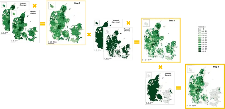
Visualisation of the three-step hierarchical approach to developing the prioritization tool
Read the report (pdf).
A basic geological complexity map for use in the implementation of the MapField concept
By Sandersen, P.B.E., 2021. GEUS Report 2021/37.
The ‘Geological Complexity Map’ presented in this report subdivides the Danish onshore area in four classes of expected geological complexity. The map is a basic, low-resolution map based on existing maps with added general and specific geological knowledge. The map is exclusively intended as input to a prioritization tool for implementation of the MapField concept and only for assessments of the expected geological complexity in and around selected ID15 catchments (approximately 1500 hectares each).
Basically, the geology at a given location consists of ‘stacked’ landscapes and associated geological layers, and therefore the geological complexity of the subsurface can be considered as a combination of the complexity of the individual, stacked landscape types. For simplicity, the geological complexity map is focused on the uppermost 30 m, because this is the interval in which most nitrate retention takes place.
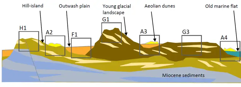
Sketch of superimposed landscape types.
Read to the report (pdf)